2024 Updates:

06/27/2024: As of 9:00am, water surface elevation is 992.11.
06/19/2024: As of 8:00am, water surface elevation is 992.297.
06/18/2024: As of 9:00am, water surface elevation is 992.31.
06/17/2024: As of 9:00am, water surface elevation is 992.286 (NGVD29 datum). Pleasant Lake outlet is currently closed. We will continue to watch the water levels closely as heavy rain is forecasted this week.
06/14/2024: As of 2:00pm, water surface elevation is 992.263.
06/13/2024: As of 9:00am, water surface elevation is 992.298.
06/11/2024: As of 9:00am, water surface elevation is 992.256.
06/10/2024: As of 9:00am, water surface elevation is 992.178. Water rose above the cut-off overnight and the Pleasant Lake outlet is being closed this morning. 06/07/2024: As of 5:00pm, water surface elevation is 991.794. We will regularly monitor the lake level over the weekend as lake levels continue to rise. 06/07/2024: As of 9:00am, water surface elevation is 991.738. While still below the cutoff, this is the highest we have seen Grass Lake this season. 06/06/2024: As of 8:00am, water surface elevation is 991.59.
06/05/2024: As of 8:00am, water surface elevation is 991.49.
06/04/2024: As of 9:00am, water surface elevation is 991.29.
06/03/2024: As of 8:00am, the lake elevation is 991.22. We saw a sharp increase due to the rain last night and will continue to watch closely with forecasted rain the next few days. We are currently well below the cutoff for closing the Pleasant Lake outlet.
5/24/2024: As of 3:30pm, the levels have risen a little due to the rainfall but are still well below the cutoff point where the outlet at Pleasant Lake would be adjusted. We will continue to watch and are ready to take action if needed over the the holiday weekend.
5/23/2024: Grass Lake Elevation Update - the water level is starting to drop after the rains earlier this week. We will keep watching the levels and keep you updated as needed over the holiday weekend.
5/22/2024: As of 2:00pm, the elevation has risen to 991.16 after the rain from yesterday. Staff are watching the levels closely and will continue to update. The levels are still below the need to adjust the outlet at Pleasant Lake.
5/21/2024: As of 7:00pm, water surface elevation is 991.07
5/21/2024: As of 10:00am, Grass Lake elevation is 991.05 (NGVD 29 datum). While we are still seeing a downward trend, staff is watching the lake elevation closely with the recent heavy rain events.
5/15/2024: As of 2:00pm, water surface elevation is 991.32.
5/14/2024: As of 1:00pm, Grass Lake elevation is 991.38 (NGVD 29 datum).
5/13/2024: as of 10:00am, Grass Lake elevation is currently 991.45 (29 datum). We've been watching the lake level slowly decline over the weekend, and will continue to watch the elevation and trends closely.
5/10/24: As of 1:00pm today, water surface elevation is 991.58.
5/9/2024: As of 6:00am today, Grass Lake elevation is 991.60.
5/6/2024: As of 4pm today, Grass Lake elevation is steadily rising. Current elevation is 991.64 (29 datum). Check back here or on Facebook for continued updates.
5/3/2024: As of 1:00pm today, Grass Lake elevation is 991.52 (NGVD 29 datum). The Pleasant Lake outlet is currently open, and staff is monitoring the water level regularly as we approach the cutoff to close the outlet.

6/18/2024: Grass Lake Dam
|
The CRWD watches the lake level near the dam on Grass Lake because a DNR permit requires the watershed to close the outlet at Pleasant Lake when the elevation at Clearwater Lake reaches 992.13'. This is called the "cutoff" elevation. We can have a good estimate at what the Clearwater Lake elevation is based on the info at Grass Lake since they are connected by a channel. The water level at the Grass Lake Dam site is monitored continuously from approximately May to October each year. We use a device called a pressure transducer which is hooked up to an antenna and this sends us the data once per hour. We also have a staff gauge (a fancy term for a ruler) attached to the dam where we can verify that the information we are getting from the transducer is accurate.
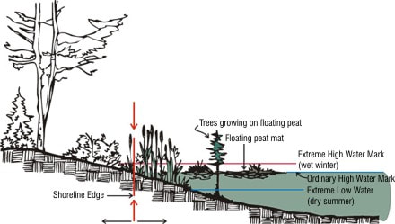
The Ordinary High Water level (OHW) on Clearwater Lake is 991.3' and on Grass Lake is 990.9'. The OHW is defined as a location around the lake where there is a change in soil and vegetation that shows us where the water usually meets the land. The highest recorded water level on Clearwater Lake was 996' and Grass, it was 995.23'. These both occurred on 6/27/1983.
2022: The rains of mid-May in 2022 caused water levels to rise rapidly. After a peak of 993.00' on 5/18/2022, water levels started to recede and have continued to do so at a slow but steady pace. In June and early July, floating bogs caused issues at Grass Lake Dam and in Clearwater Lake. The bogs were pulled out from around the dam. Low precipitation has kept lake levels right around the OHW since mid-July 2022.
**All elevation information is being reported in NGVD29 datum. If you use NAVD88 datum, you would add approximately 0.5' to the elevation numbers listed here.